Drones+ 아이폰앱 제작자인 Josh Begley의 작품.
(Drones+에 대한 한국기사: http://www.bloter.net/archives/136377)
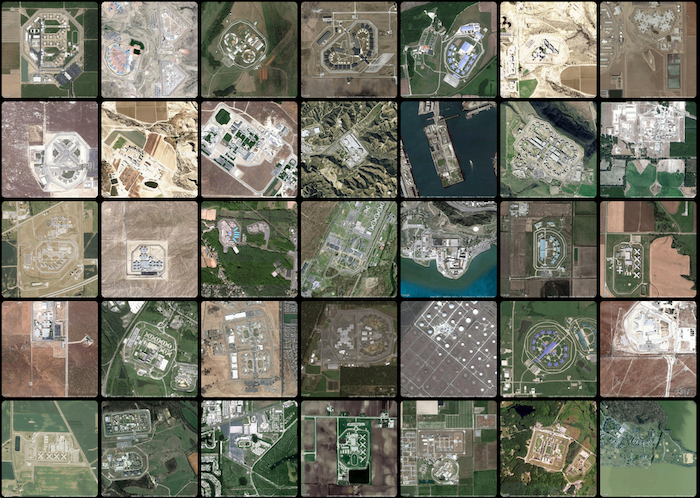
출처: http://prisonmap.com/about
About
Prison Map is not a map -- it's a snapshot of the earth's surface, taken at various points throughout the United States. It was made by Josh Begley, a graduate student studying Interactive Telecommunications at New York University.
* * *
The United States is the prison capital of the world. This is not
news to most people. When discussing the idea of mass incarceration, we
often trot out numbers and dates and charts to explain the growth of
imprisonment as both a historical phenomenon and a present-day reality.
But what does the geography of incarceration in the US actually look like? Prison Map is my attempt to answer that question.

The project came about in a Data Representation class with Jer Thorp
at NYU. It begins from the premise that mapping the contours of the
carceral state is important. A number of people and organizations have
done excellent work in this regard. Among them are the Prison Policy Initiative and Prisoners of the Census.
Over the past few years, they have culled together a database of
seemingly mundane but hard-to-locate information: the latitude and
longitude of every carceral facility in the United States (currently
with the exception of WA, WV, WI, and WY). Their locator tool,
which aims to identify correctional facilities counted in the 2010
census for the purposes of accuracy and redistricting, is the first
database I know of to include state and federal prisons alongside local
jails, detention centers, and privately-run facilities. You can explore
their facility locator here.
When using the tool, however, it was hard for me to get a sense of
volume -- what does it mean to have 5,000 or 6,000 people locked up in
the same place? What do these carceral spaces look like? How do they
transform (or get transformed by) the landscape around them?
In order to begin answering some of these questions, I started playing with satellite imagery. The Google Maps API
allows you to pass any latitude and longitude into its Static Maps
service, specifying parameters such as format and zoom level, and it
will spit back an image of that particular location. With Jer's help, I
wrote a simple Processing sketch that would grab image tiles at various lat/lons, save them as a .jpg file, and cycle through all 4,916 facilities:
String[] prisons;

void setup() {
}

void draw() {
  prisons = loadStrings("prisons-latlon.csv");
  for(int i = 0; i < prisons.length; i++) {
    String[] values = split(prisons[i], ",");
    String lat = values[0];
    String lon = values[1];
    String id = values[2];
    PImage test = getSatImage(lat,lon);
    test.save("facility" + id + ".jpg");
  }

}

PImage getSatImage(String lat, String lon) {
    String url = "http://maps.googleapis.com/maps/api/staticmap?center=" + lat + "," + lon + "&zoom=
    16&scale=1&size=640x640&maptype=satellite&sensor=false&junk=.jpg";
    return(loadImage(url));
}
Not all of the coordinates are perfect. Also, because there are so many images, the webpage takes quite a while to load. For this reason, I've only included about 700 (14%) of the best photos. If you want to see the entire data set, you can do so here.
Questions or comments? Email me: josh.begley[at]nyu.edu.
'Programming > Web' 카테고리의 다른 글
| 감사합니다 이미지 (0) | 2014.02.04 |
|---|---|
| [펌] ASP.NET-DataGrid를 간단하게 Excel로 변환하기 (0) | 2012.11.29 |
| [펌] mysql vs mysqli 속도 테스트 (0) | 2012.11.21 |


